2. Chapter- The Role of the Basra-Hormuz Plain Play in Humanity's Transition from Wildlife to Social Life
The first humans appeared in East Africa 2.5 million years ago. People lived by hunting and gathering during the stone age. A family in such a lifestyle requires an area with a diameter of about 10km. As the human population increases, new generations must migrate to other places. For this reason, the people who originated in East-Africa began to disperse in all directions from there. Of course, they first spread to Africa, but they also spread to countries such as Arabia, Asia, and Europe by migrating along the seaside.
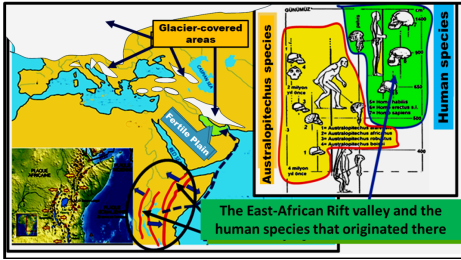
Figure 1. Various species of bipeds (hominids) over the last 5 million years (Modified from Gedik 1998).
The genus called Australopitechus, with a brain of about 500cm
3, is the world's first bipedal, hunchbacked walking creature. Later, different human species came to life, starting with Homo habilis with a 650cm
3 brain, continuing with Homo erectus with a 900cm
3 brain, and continuing with Homo sapiens with a 1400cm
3 brain. In other words, humanity is a living species that has been freed from primitiveness by increasing its brain capacity (
Figure 1).
Homo habilis lived only in Africa. Homo erectus and Homo sapiens also spread to Asia and Europe.
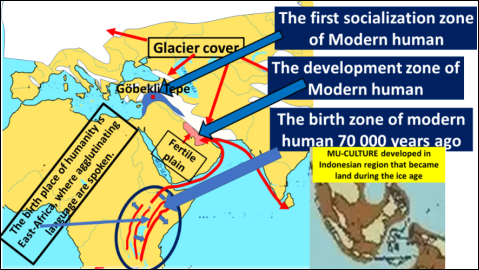
The Neanderthal variant of Homo sapiens spread to Asia and Europe around 300,000 years ago. About 70,000 years ago, a newer variant of Homo sapiens - Homo sapiens sapiens emerged, which in turn spread to Asia and Europe.
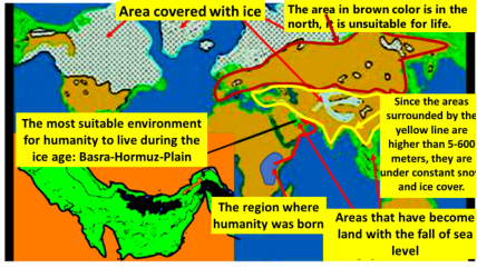
Our world went through an ice age between 115,000 and 15,000 years, and during the ice ages, the Geography of Earth was as on the map. In the northern regions of America, Europe and Asia there was a 2.5km thick ice cap. Since glaciers are formed as a result of the evaporation of water in the seas and storage on land as snow and ice, the water level in the seas is low enough to correspond to the amount of glaciers on land; This means a sea level drop of about 130m! As such, the seas have receded from the coastal area called the continental shelf, and shallow marine environments have turned into land (
Figure 2).
Figure 2. GLACIAL CYCLES play a very important role in the history of human development. BROWN region of Europe and Asia is very cold because it is far from the equator. The region, which is bordered by yellow colour, is under constant snow-ice cover because it has a very high altitude.
The ice age coincides with today's BLACK-WINTER: There is snow in all regions of such as the Iranian plateau and Anatolia at all altitude of more than 200-300 meters. Therefore, it is almost impossible to live there. During the last Ice Age, which lasted a hundred thousand years, the regions suitable for human life in Europe and Asia are also very limited. There are not enough food sources for people who must make a living by hunting animals and gathering wild berries.
Since humanity did not yet know how to make pottery until 8,500 years ago, it could only live in caves or temperate climates located around water sources. Areas that meet these two conditions are places close to the equator and near the edges of a river valley, with a height of less than three to four hundred meters.
For people who do not yet know how to make pottery, the Basra-Hormuz-Plain is an ideal environment, because the Tigris-Euphrates River irrigates the entire plain. It is located closest to Africa and has a temperate climate and is protected from the northern winds by the Zagros mountains. Majority of people migrating from Africa first settle there and begin to multiply
| [21] | ROBERTS, N. Pleistocene environments in time and space. In R. Foley, ed. Hominid evolution and community ecology. Academic Press London, 1984: s. 25-53. |
| [22] | Swift, S. A. and Bower, A. S. Formation and circulation of dense water in the Persian/Arabian Gulf. Journal Of Geophysical Research. 2003; VOL. 108, NO. C1, 3004, https://doi.org/10.1029/2002JC001360 |
| [24] | Yao, F., "Water Mass Formation and Circulation in the Persian Gulf and Water Exchange with the Indian Ocean". Open Access Dissertations. 2008; Paper 183. |
[21, 22, 24]
.
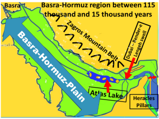
The Persian Gulf is one of the environments that turn into land. It has been replaced by a huge fertile alluvial plain, which will be called the Basra-Hormuz-Plain. Near the Strait of Hormuz, there is a large lake with many islands on it. People who come here begin to live in two different environments: one part begins to live on the huge flat plain, and the other part begins to live on islands in the lake
| [13] | HAYS, J. D., IMBRIE, J. ve SCHACKLETON, N. J. Variations in the earth’s orbit: pacemaker of the ice ages. Science. 1976; 194, s. 1121-1132. |
| [14] | IMBRIE J., HAYS J. D., MARTINSON D. G., McINTYRE A., MIX A. C., MORLEY J. J., PISIAS N. G., PRELL W. L., ve SCHACKLETON N. J. The orbital theory of Pleistocene climate; Support from a revised chronology of the marine delta 18O record. In BERGER A. L. ve diğ., eds.. Milankovitch and climate; understanding the response to astronomical forcing. Boston, Reidel. 1984; Part I, 169-305. |
[13, 14].
The futures of these two groups will be different (
Figure 3).
The plain is very large, but people can only benefit from a 10km strip of the 200km wide plain, because it is impossible to find water in the hundreds of km. away from the riverbank. Since the Tigris-Euphrates, which flows in the plain, flows in the south-east direction starting from Basra, it is possible to open channels along the river and deliver water to all parts of the plain. Realizing this, people began to dig water channels all over the plain, in cooperation, to make room for the growing population. This is a must. Just as atoms in a difficult situation in laser technology enter cooperation, people have taken the first step of socialization by cooperating with each other in the face of this necessity due to the physics of dynamical systems
| [11] | HAKEN, H., 1983; Synergetics. Springer. 1983. |
| [12] | HAKEN, H. Information and Self-Organization. A Macroscopic Approach to Complex Systems. Springer Verlag. 2000; 222 pp. 62 figs. |
[11, 12].
Figure 3. The most suitable place for human life during the ice age is the Basra-Hormuz Plain.
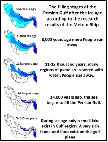
The ice age ends about 15,000 years ago and the sea level begins to rise by 1.1cm every year due to the melting of the glaciers. An annual sea rise of 1.1cm begins to affect people living on a flat plain very much in a few years. We can explain this as follows.
The Basra-Hormuz-Plain is about 800km long, but there is only a 70-meter elevation difference between Basra and Dubai. In other words, the plain is almost flat, its slope is 70/800 000 = 0.0000875. When the sea level rises by 1.1cm each year, the inhabitants of the plains must move 120 meters away from the coast every year. This means a huge loss of living environment. For this reason, those living in the areas covered by the sea had to flee and migrate every year.
Therefore, people living in this Plain during the ice age until 15,000 years ago were exposed to continuous migration between 14,000 and 7,000 years ago. Because it took so long for the Persian Gulf to be filled. It is understood from archaeological data
| [1] | BRAIDWOOD, R. J. Prehistoric Man - Tarih Öncesi İnsan. Arkeoloji ve Sanat Yayınları. 1995; 290 s. |
[1]
that the Fertile Crescent region is at the beginning of the place where the people fleeing from the plain migrate. The culture created by the people of Göbekli-Tepe and Karahan-Tepe 11-12 thousand years ago is definitely an indication that they were experienced in socialization before.
The Sumerians were the first people to provide information about their past by creating written documents. In these inscribed clay-tablets, they wrote that they came from the sea to the land of two rivers
| [3] | CERAM, C. W. Götter, Graeber und Gelehrte. Rowohlt. 1972; 447 s. |
[3]
.
Since humans could not live in the sea, it has always been a mystery where the Sumerians came to the Basra Region. Because until 15,000 years ago, it was not known that the sea completely receded from the Persian Gulf and turned into an alluvial plain during the ice age (
Figure 4).
Figure 4. The Persian Gulf, which became completely land during the ice age, begins to be covered by the sea again 14 thousand years ago and the sea transgression continues until 7 thousand years ago. (Meteor ship surveys).
The stages of the refilling of the Persian Gulf with the sea after the ice age can be seen in the research carried out by the Meteor research ship in the region
| [19] | Meteor-Forschungsergebnisse. - Borntraeger Reihe C. Geologie und Geophysik / Red.: E. Seibold u. H. Closs No. 4. Oberflächensedimente im Persischen Golf und Golf von Oman. 1. Geologisch-hydrologischer Rahmen und erste sedimentologische Ergebnisse. Von M. Hartmann [u.a.] 1971. 76 S., mit Ktn.: Mit 47 Abb. u. 12 Tab. im Text. |
[19]
.
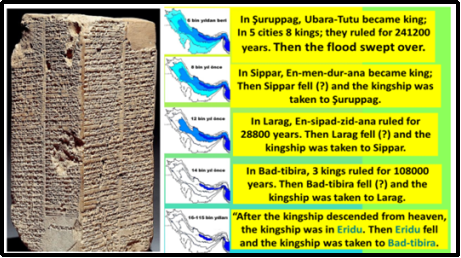
The most important of the clay tablets, called the cuneiform script of the Sumerians, which has been preserved without being erased or destroyed until today, is the "List of Kings". On this prism-shaped tablet, it is written who ruled their society as Kings in their past (
Figure 5).
Figure 5. Weld-Blundell Prism, King List tablet, Ashmolean Museum, Oxford England, found in Larsa-Irak.
They divided their history into two distinct periods:
a. Before the flood and
b. After the flood.
In the pre-flood period, they lived in 5 different cities; It is noted that over time, cities “fell=drowned" and the ship of the kingdom was moved to another place. It is written that at the end of a great flood, the last city was submerged, and after this flood, life continued with new kingdoms around Basra.
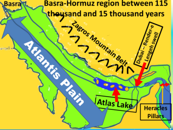
This information is consistent with geological information because there was a very long ice age until 15 thousand years ago. During this long ice age, some of the people who came to the Basra-Hormuz-Plain lived on the islands in the lake, which is located close to the Strait of Hormuz. The deepest place in the Persian Gulf is 90 m. But an undersea ridge called the Dubai-Bender-E-Lengeh threshold prevents waters deeper than 70 meters from draining. For this reason, a lake with a depth of 20 meters remains, which is shown in the (
Figure 6).
Figure 6. ATLAS-LAKE in Glacial Periods at Basra-Hormuz Plain.
Let's call this lake, which does not exist today, the Atlas Lake. There are many islands in the lake because there are layers of anhydrite in the basement rocks of the Basra-Hormuz-region, and when they take water and swell, salt-dome-shaped bumps appear. For this reason, there are many bumps in the entire Basra-Hormuz-plain that will form islands during the rise of the sea.
When the ice age ended, it is understood from the Meteor ship surveys that the sea level rose by 1.1cm every year in the Persian Gulf because of both the melting of the 2.5km thick glaciers at the north pole and the melting of the glaciers on the Zagros Mountain tops.
The annual sea rise of 1.1cm does not affect the Sumerians living on the island, because only 1.1cm of an island 30-40 meters high is covered by the sea. For this reason, the inhabitants of the island continue to live on their islands for thousands of years. However, there is also a very thick ice cover on the Zagros Mountains in the north of the region, and the melting of these glaciers affects the people living on the islands in the lake, because the melting snow and the soils on the ground under the ice cover also mix with the melting waters, causing muddy floods.
These muddy floods, which are repeated every year, last for years because it takes more than three thousand years for an island 30-40 meters high to sink into the sea. For thousands of years, the inhabitants of the island had to deal with floods of mud of one to a few meters every year. In this long process:
1) It leads to the fact that the mountain slopes covered with plants become more and more bare.
2) The lake gradually fills with mud and ceases to be a lake and turns into a swamp.
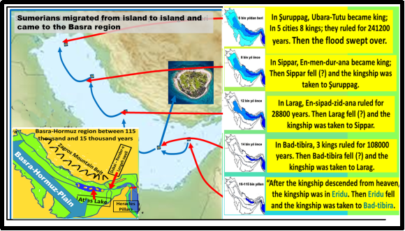
These muddy floods, which are repeated every year, cause great damage in places such as gardens on the edges of the island. People must have tried to protect themselves against these disasters by building walls around the island. In this way, the people who lived by building a wall around the island for many years must have understood that their island would be completely submerged in the next few years, so they migrated to another island further north by making rafts and boats (
Figure 7).
Figure 7. The Sumerians began to live on islands in the Lake Atlas, and when their island was buried in the sea due to transgression, they migrated to another island further north and landed on the shores of Basra.
The fact that this assumption is correct is understood from the mention of 5 ancient kingdom centres listed in the first part of the Sumerian Kings-list tablet (Eridug- Larag- Sippar- Syrupak- Basra after the Flood). At the end of the ice age, when the sea level rise caused by the melting of the glaciers caused the island in the lake to sink, the inhabitants migrated to another island further north by boat, etc. Thus, life continues in the form of moving to 5 different cities. Finally, life on the island ends with a great flood. Because the glacier masses that remain in the last stage of the melting of mountain glaciers cause the greatest flood disasters, because they are like balloons filled with water (Glacier outburst floods), and when they burst, they drag everything in their path and carry them to the sea, like dams that collapse. The last pack of glaciers remaining on the tops of the Zagros mountains had this effect and buried the island where the Sumerians lived. These statements are conclusive evidence that the Sumerians lived on the islands and migrated to another island further north as the islands sank
| [2] | BRENTJES, B. Völker am Euphrat und Tigris. Koehler & Amelang, Leipzig. 1981; 263 s. |
[2]
The Sumerians went out to the vicinity of Basra after the flood and in a tablet they emphasize that they came to the region of "two rivers from the sea"
| [3] | CERAM, C. W. Götter, Graeber und Gelehrte. Rowohlt. 1972; 447 s. |
[3]
. Archaeological findings show that the Sumerians came to the Basra region about 6 thousand years ago. Sumerian tablets were written by Sumerian thinkers-scribes after the Sumerians landed in the Basra region and discovered writing 5500 years ago.
Archaeological data shows that a society called the Sumerians emerged around Basra about 6,500 years ago and established city-states 5,500 years ago. In other words, when the Sumerians came to the Basra region, they did not immediately establish the system called STATE, which was owned and managed from the top, but established holy kingdoms after many years.
If we summarize the data presented above, then the following situation arises:
1) Humanity took the first step in the transition from wildlife to civilized life in the Basra-Hormuz-Plain.
2) In the part of the Basra-Hormuz-Plain near the Strait of Hormuz, there is a large lake that can be called Atlas, and there are islands in this lake. This lake is located in the interior of the Strait of Hormuz, which opens to the Indian Ocean.
3) There are islands in this Atlas Lake, from which you can pass to each other and to the huge surrounding plain.
4) To the north of the lake there is a very large mountain range (Zagros mountains), which protects the islands and the plain from the northern winds. This high mountain range extends into the sea like a tongue near the Strait of Hormuz. The Tigris-Euphrates River flows next to it.
5) With the end of the ice age, the glaciers on the peaks of the Zagros mountains began to melt and floods occurred every year. Since the melting snow and the soil under the ice cover were mixed with the floods along with the waters, the mountain slopes were left bare.
6) Muddy floods that lasted every year filled the Atlas Lake over time and turned it into a swamp.
7) Around the lake there is a rectangular plain with a size of 800 x 200km. Water channels have been opened to benefit from all parts of this plain.
8) Since the plain is an alluvial plain, all kinds of plants can grow in abundance.
9) 14,000 years ago, as the sea began to fill the plain again, the people in the plain began to flee.
The above paragraphs have been prepared according to today's geological and archaeological data.
The following information is a summary of the works “Timaeus and Critias” of the Greek philosopher Plato
| [5] | EFLATUN, Timaios (Çevirenler; Erol Güney ve Lütfü Ay), Milli Eğitim Bakanlığı Yayınları 1133, Ankara, 1989. |
| [6] | EFLATUN, Critias (Çevirenler; Erol Güney ve Lütfü Ay), Milli Eğitim Bakanlığı Yayınları 905, Ankara, 1989. |
[5, 6]
.
1) Before BC. 9600, there was a sea called the Atlas, which could be crossed by ships; The Atlas sea is located on the inner side of a strait that opens into a very large ocean.
2) On the side of this Atlas Sea near the strait, there is an island called Atlantis. From this island, you can go to other islands and the land surrounding the lake.
3) The land surrounding the lake is large and bordered with very high mountains. These mountains protect the islands and the plain around the lake from the northern winds. This high land (where the strait is) extends into the sea like a tongue and a river flows next to it.
4) There have been many floods in the past, and with these floods there have been such landslides that the slopes of the surrounding mountains have been bare and bare.
5) The Atlas Sea has become increasingly swampy due to constant floods that occurred every year.
6) There is a rectangular plain around the lake; its size is 540 x 190km, this entire plain is surrounded by a deep and wide water channels. There are also many other water channels that cut the entire plain transversely and longitudinally.
7) In the country (on the plains and islands) there is the most fertile land in the world, so that all kinds of plants and vegetables can be grown; And it is so abundant that even animals such as elephants can be fed. The climate is so suitable that all kinds of spices and fruits (pomegranates, citrus fruits, coconut, etc.) are grown.
According to the right and law of priority the name of the Basra-Hormuz-Plain should be changed to the Atlantis-Plain, because Plato gave a very concise human development more than 2500 years ago in his books Timaeus and Critias, and what is written is in line with today's knowledge.
For this reason, the term Atlantis-Plain will be used in the following sections.
3. Chapter- How Can We Find the Trace of Atlantis Culture
Humanity has learned mutual interaction, solidarity, and cooperation during the 50 thousand years of life they have spent in the Basra-Hormuz-Plain. It is exactly the expected result that the civilization of the Fertile Crescent region, where points such as Göbekli-Tepe, Karahan Tepe, etc. of South-Eastern Anatolia are the centre, was created by people with such an experience.
The language spoken by the Atlantis-people.
In order to understand what the future of the Atlantis people was like, it is enough to know what language they spoke in their past. Because a comparison can be made with the languages spoken by the people scattered throughout our world.
Since humanity originated in East-Africa, it is expected that the language spoken in that region will continue to be spoken in the places where they migrate. As a matter of fact, researches showed that the oldest languages are in Central and Southern Africa and that other languages closely follow the migration routes of Homo s. sapiens, which spread from Africa to the world, as a result of the analysis of 504 world languages in terms of phonetic complexity
| [9] | Gray R. D. & Atkinson Q. D. Language-tree divergence times support the Anatolian theory of Indo-European origin. Nature. 2003; volume 426, pages 435-439. |
[9]
.
As shown on the map, languages belonging to the Bantu language group are spoken in this region today. One of them is the Swahili language. Swahili, like all other Bantu languages, is an agglutinated language, and its characteristics will be presented below (
Figure 8).
Figure 8. Birthplace of humanity.
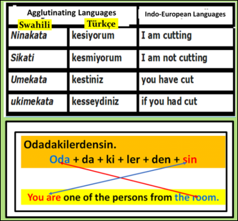
As an example, the table below shows how different the English language is, while the similarity of Swahili and Turkish, which are agglutinating languages, is shown (
Figure 9).
Figure 9. Comparison of agglutinating and Indo-European languages.
The main feature of agglutinating languages is that the word "Odadakilerdensin" has been transformed into a sentence such as "You are one of the persons from the room" in Indo-European languages, which are a fragmented language group.
Let's compare these two language groups (
Figure 10):
Figure 10. Comparison of the Word order in a sentence in different language groups.
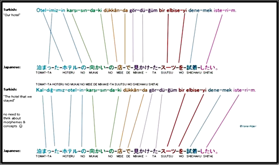
Now let's show how widespread the language of the people living in a very distant Asian region such as Japan and the languages with similar structures and attachments to Turkish are in the world: A native Turkish speaker and a Japanese learner (Selcuk Yilmaz, who works as a programmer in the US) has shown that there are structural similarities between the Japanese and Turkish languages. For example, the word order is almost identical (
Figure 11).
Figure 11. Comparison of two language separated over long distances but belonging to the same group.
Compared to English, the difference is striking: the grammar is also somewhat similar to Turkish. Since both are agglutinated languages, they share the same logic.
The last representatives of the Atlantis people to land on the shores of Basra were the Sumerians. And it is clear from their written documents that the Sumerians used an agglutinating language
| [22] | Swift, S. A. and Bower, A. S. Formation and circulation of dense water in the Persian/Arabian Gulf. Journal Of Geophysical Research. 2003; VOL. 108, NO. C1, 3004, https://doi.org/10.1029/2002JC001360 |
[22]
. So the Atlantis people must have used an agglutinated language. Therefore, the people who fled from the Plain of Atlantis and spread to Europe and Asia must have an agglutinating language.
As a matter of fact, it has been observed that the people who crossed to America through Asia have agglutinating languages. Ex. Among the quechua peoples living in the Peruvian Andes and the mountainous regions of South America, a fully agglutinated language is spoken: Maqachinakurkan = They let each other be beaten.
The following are examples of the prevalence of agglutinated languages (from Wikipedia):
1) Niger-Congo languages. Bantu languages.
2) Turkic languages. Turkish.
3) Basques language,
4) Finnish, Estonian, Hungarian.
5) Kartvelian languages. (Georgian, Laz)
6) Dravidian languages. Tamil, Sanskrit.
7) Austronesian languages. Tagalog.
8) Indigenous languages of the Americas. Algonquian languages.
9) Eskimo-Aleut languages.
10) Berber languages.
In the languages that people speak, words change over time, but the general structure of the language does not change much. It is understood that the ancestors of modern humans, who emerged in East-Africa 60-70 thousand years ago, spoke agglutinated language, such as Turkish or Finnish.
4. Chapter: Where Did the Atlantis People Migrate
As shown in the previous chapter, the inhabitants of the plain were the first to leave the Plain of Atlantis, because every year the sea began to cover a very large coastline of the plain, which was flat. The people on that coastline have also started to flee (
Figure 12).
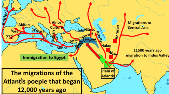
Figure 12. Migration routes of Atlantis peoples indicate that the first migration points was Fertile-Crescent 11.600 years ago, and Egyptian 10.600 years ago (1 thousand year later as written by Plato).
When the ice age ended 15,000 years ago, the sea level began to rise by 1.1cm every year and the Basra-Hormuz-Plain began to be covered with the sea again. The majority of people whose plains are covered by the sea fled to the region called the Fertile Crescent and formed the first civilized societies in the world.
4.1. How the Fertile Crescent Developed
With the melting of snow and ice cover, the Anatolian plateau becomes suitable for plant and animal development again. These regions, which were previously inhabited by many people, became the new homeland of those who migrated from the Atlantis plain
.
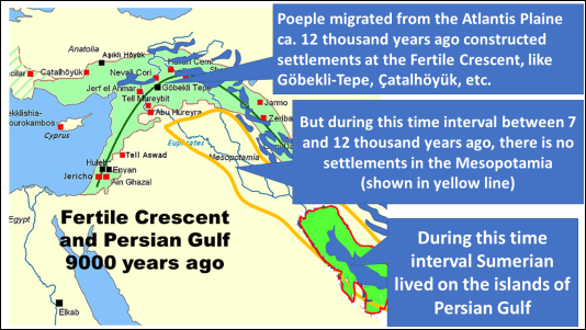
People living in the Basra-Plain during the ice age were subjected to continuous migration between 14,000 and 7,000 years ago. Because it took so long for the Persian Gulf to be filled. Regions of Anatolia such as Karahan Tepe and Göbekli Tepe, where the snow and ice cover was removed, were the first places where people who were exposed to migration settled (
Figure 13).
Figure 13. The fertile crescent is the region in which humanity started civilized life. It was created by those who came from the plain of Atlantis.
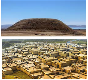
People of 5-10 thousand years ago lived in houses completely adjacent to each other. The walls of the houses were shared, so the heating was more economical. Entrances and exits to the houses were through a ladder through a hole in the ceiling. The dead people were buried in a hole dug in the floor of the house. For this reason, at the end of a certain years, the houses were completely demolished and new houses were built on them. In this way, dome-like images were formed, which gradually risen. These are called MOUNDs (Höyük) today. There is no class distinction in mound-style life, there is a social life where equality and freedom are valid.
The first settlements in Anatolia are in the Mound style (
Figure 14).
Figure 14. Civilized life started in Anatolia after 12 thousand years and lived in common living environments called HÖYÜK in equality and freedom until 4 thousand years ago.
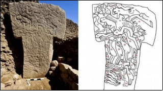
We can understand the perspective of the people living in the mounds from the reliefs and sculptures they made. It is seen in the works left by the people of Göbeklitepe, one of the oldest mounds, that they have a belief that can be called animism. By engraving many different animal Figs such as snakes, vultures, pigs and eagles on T-shaped columns weighing tons, they explained that all beings in nature have a soul. Since there is no such thing as nobility in the animistic view of life (
Figure 15), there is a common life based on equality-freedom-fraternity.
Figure 15. Societies in Anatolia before 4,000 years ago must have had an animistic view of life.
4.2. Migrations of the People from Atlantis Plain
Where could the people from Atlantis plain migrated to, being forced to migrate as a result of the end of the ice age, due to the transgression of the sea?
The answer is very clear: While the end of the Ice Age makes the Atlantis Plain uninhabitable, it also transforms previously uninhabitable places such as Anatolia, Europe, and Asia into a liveable environment. These places became the new homeland of the Atlantis peoples.
Since the language spoken in the region where Homo sapiens sapiens was born is agglutinated, the language of the people of the Atlantis-Plains, must also be agglutinating. The data supporting this view is that the languages of the societies (Sumerians, Turks, Azerbaijanis, etc.) that migrated from this plain and settled in the surrounding regions are "agglutinated". As a matter of fact, the Sanskrit language spoken further east is also agglutinated. Even the languages spoken by the native tribes of the Americas are also agglutinated. In other words, the first language spoken by humanity is definitely agglutinated.
European languages are a new language group formed in the steppe environments between Ukraine and Kazakhstan 5-6 thousand years ago.
People living in the Atlantis Plain were forced to migrate continuously from 14 thousand years ago until 7 thousand years ago. The language spoken by these immigrant people must definitely be agglutinated
| [4] | Diker, Selahi. Anadolu’da On bin Yıl, Türk Dili’nin Beş Bin Yılı. Oral Matbbası, İzmir. 2000; 562 s. |
| [23] | Tuna O. N. Sümer ve Türk Dillerinin Tarihi ilgisi ile Türk Dili’nin Yaşı Meselesi. Atatürk kültür, dil ve tarih yüksek kurumu, Türk dil kurumu yayınları 1990; 561. ISBN 975-16-0249-1. |
[4, 23].
In the past, people usually traveled along river valleys or sea coasts. The main reason for this is the fear of getting lost. Since the north of the plain of Atlantis is surrounded by a very high mountain range, it is very difficult to cross, there is still a snow and ice cover on it, and there is a high probability of disappearing. For this reason, the Atlantis peoples migrated along the following routes:
1) People going along the sea coast must reach in the easterly direction India and along the Red Sea coast direction Egypt. Those who choose this migration route to the east are blended with the Indus valley and Dravidian culture. Those who went in the direction of the Red Sea became the pioneers of the building of Ancient Egyptian culture.
2) Those who migrated to the north-west along the Tigris-Euphrates valley, which would lead to the formation of Anatolian and European societies, will be discussed in a separate section below.
3) Those who go north from the point where the Zagros Mountains end are the Turkic-speaking communities such as Qashqais, Afshars, Halachs, and Khorasans who still live in Iran today on the Iranian plateau and are the first inhabitants of those regions. One branch of them goes to the north-west and forms the Azerbaijanis. Another part of them continue towards Central-Asia and form the Central-Asian Turks. In other words, a tribe that speaks a language called Persian and belongs to the Indo-European language group came to Iran much later
. This topic will be discussed in a later section.
The Atlantis lowlands were subject to continuous migration between 14,000 and 7,000 years ago, because that's how long it took for the Persian Gulf to fill. And 6-7 thousand years ago, a tribe called the Sumerians - which is stated to be at a very advanced level of civilization compared to the other tribes in the vicinity - came to the vicinity of Basra [
16-18]. This tribe later wrote in their cuneiform tablets that they "came from the sea to the region of two rivers"
| [3] | CERAM, C. W. Götter, Graeber und Gelehrte. Rowohlt. 1972; 447 s. |
[3]
.
As can be understood, the tribe called Sumer continued their lives by living on the mounds on the plain of Atlantis until the Persian Gulf was completely filled. However, most of the people living in the flat plain had to leave the plain much earlier and migrate to other regions. (Göbekli tepeli, Çatalhöyüklu, Azerbaijanis, etc.
The places where the Atlantis people migrated are shown on the map presented above. The evidence that migrations took place on these routes is given by the analysis of the languages spoken by today's societies and the results of genetic haplogrub analysis.
4.3. Opening of Anatolia and Europe to Settlement by the Atlantis-People
Today, there is a very wrong view that the first people of Anatolia were Greeks. This is the result of complete ignorance. Because the first indigenous people of both Anatolia, Thrace, the entire Aegean region and the Balkans were the Atlantis-People, who spoke agglutinated language like Turkish, Ungarish and settled in these regions from 12 thousand years ago until 7-8 thousand years ago. The so-called Greek tribe is an invading society consisting of the Yamnaya-Nomads in the north and descended on the indigenous tribes in the south from the Ukrainian region 3700 years ago.
People who had to flee from the Atlantis Plain settled first in the Fertile Crescent region and Anatolia. Turkmens and Yörüks were the first tribes. Those who fled to the north-west along the Tigris-Euphrates valleys became the first inhabitants of the northern regions, such as the Anatolian plateau, which were uninhabitable during the ice age
| [7] | GEDİK, İ. Atlantis; Efsanevi batık kent nerede? Türklerle ilişkisi var mı? Cumhuriyet Bilim Teknik. 1992; sayı 285, s. 8-10, İstanbul. |
[7].
Recent archaeological findings have shown that the oldest socialization points were 12 thousand years ago in Southeastern Anatolia regions such as Göbekli Tepe, Karahan Tepe, and Hallan Çemi. The people who started social life at these points had not yet discovered agriculture and animal husbandry, but they had reached the concept of "life partnership". And they had attained this ability on the Atlantis plain. Because, in order to be able to live on all sides of the huge plain, they had come to the knowledge of seeing and accepting the people around them not as rivals, but as partners who would carry out the construction of water channels all over the plain. This is how the first social behaviour began, and the place where it first started was the Basra-Hormuz plain, in other words, the Atlantis Plain.
With the end of the ice age, when the Atlantis Plain began to be covered with the sea again, people left the plain and began to look for new living environments.
Anatolia is one of the new living environments, because Anatolia, which was under snow and ice during the ice age, turned into new living environments with the melting of snow and ice. The people of the plain of Atlantis are also aware of this, because the flint traders based in Anatolia pass this information on to them.
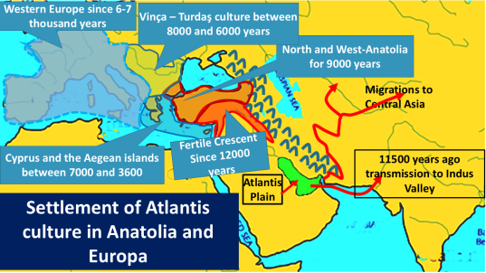
For this reason, the first socialization in the world started 12 thousand years ago in a belt called the Fertile-Crescent, where South-eastern Anatolia is the centre, as shown in the map presented (
Figure 16).
Figure 16. Modern humans reached Anatolia 12 thousand years ago, but they were able to cross into Europe between 8,000 and 6,000 years ago.
It takes 3 thousand years for the whole of Anatolia to be opened to settlement. For this reason, the first settlements in northern and western Anatolia began to form about 9 thousand years ago. The whole of Anatolia is therefore the first homeland of the Atlantis Plain immigrants, because the places where they lived before (the Atlantis Plain) were covered by the sea, they were forced to migrate and became the first inhabitants of this previously snow-covered region. This is how the core of Anatolian societies was formed.
People from Göbekli-Tepe and Sumerians are the transmissions of this Atlantis Culture. Therefore Atlantis is not a myth, but a reality. And Egyptian culture developed thousand years later than Fertile Crescent culture, then the transmission of Atlantis culture to Nile delta takes much more time.