Ground-penetrating radar (GPR) has emerged as a valuable non-invasive technique for detecting and delineating unmarked graves, particularly in arid and semi-arid environments where preservation conditions differ markedly from humid settings. The Islamic religion forbids excavating graves or moving human remains, as such, GPR represents an effective method to determine grave characteristics including burial depth, size, type, and orientation of caskets, as well as the distribution and number of graves within a particular area. This study evaluates the effectiveness of GPR in identifying subsurface grave features within dry climate regions, where low soil moisture, limited vegetation cover, high electrical resistivity, and minimal organic decomposition can influence radar signal behavior. Grave characteristics including depth of burial, size, type, and orientation of caskets, as well as the quantity of graves in a given region and the geographic distribution of burials within a particular area, may frequently be ascertained using (GPR). In this study, two unmarked grave sites were surveyed using a SIR-20 GSSI (GPR) instrument. The number of graves and precise locations were unknown due to the lack of historical information. GPR data were acquired using multiple antenna frequencies to optimize the balance between radar penetration depth and resolution. Two anomalies representing possible unmarked adult graves and one unmarked infant grave were identified by two-dimension two-dimension (B-scan) and three -dimensions (C-scan) cross –sections. The anomalies ranged from 0.6 to 1 meters in depth, with lateral dimensions of 0.6 to 2 meters is typical for individual burials. All mapped anomalies have northwest-southeast orientation consistent with Islamic burial practices.
| Published in | International Journal of Archaeology (Volume 14, Issue 1) |
| DOI | 10.11648/j.ija.20261401.12 |
| Page(s) | 5-15 |
| Creative Commons |
This is an Open Access article, distributed under the terms of the Creative Commons Attribution 4.0 International License (http://creativecommons.org/licenses/by/4.0/), which permits unrestricted use, distribution and reproduction in any medium or format, provided the original work is properly cited. |
| Copyright |
Copyright © The Author(s), 2026. Published by Science Publishing Group |
Ayn Gharandal, Unmarked Graves, Ground Penetrating Radar, Three Dimensions
GPR | Ground-Penetrating Radar |
| [1] | Abbas M., Ghazala H., Hany S. Mesbah H. S., Atya M., Radwan A., Hamed D. A. Implementation of ground penetrating radar and electrical resistivity tomography for inspecting the Greco-Roman Necropolis at Kilo 6 of the Golden Mummies Valley, Bahariya Oasis, Egypt. NRIAG Journal of Astronomy and Geophysics. 2016, 5, 147–159. |
| [2] | Abueladas, A. A., and Akawwi E.. Ground-penetrating radar inspection of subsurface historical structures at the baptism (El-Maghtas) site, Jordan. Geoscientific Instrumentation, Methods and Data Systems. 2020, 9(2), 491-497. |
| [3] | Abueladas, A. A. Assessment of seismic hazards along the northern Gulf of Aqaba, PHd thesis, University of Missouri Kansas City. 2014, 135. |
| [4] |
Allison A. Paleoseismology and Archaeoseismology along the Southern Dead Sea Transform in Wadi 'Arabah Near the municipality of Aqaba, Jordan. UMKC Dissertation. 2013.
https://mospace.umsystem.edu/items/2ae0653e-daa5-4b69-a017-e673cf78685c |
| [5] | Annan, A. P. Electromagnetic principles of ground penetrating radar. In Ground penetrating radar: Theory and applications Elsevier Science. 2009, 1–40. |
| [6] | Annan, A. P. 2002. GPR History, Trends, and Future Developments. 2002, 3, 253–270. |
| [7] | Berezowski, Mallett V., Ellis J., Moffat I. Using ground penetrating radar and resistivity methods to locate unmarked graves: a review, Remote Sens. 2021, 13, 15 |
| [8] | Bevan, B. W. The search for graves, Geophysics. 1991, 56(9), 1310–1319, |
| [9] |
Cheetham, P. Forensic Geophysical Survey. In: Hunter, J. and Cox, M., eds. Forensic Archaeology [online]. Abingdon-on-Thames: Routledge, 2005, 62–95.
https://www.taylorfrancis.com/books/9780203970300 [Accessed 10 Nov 2017]. |
| [10] | Cristino, K., Doro, K., Armstrong, A., Forbes, Sh, Gayon, A., Georg Bank, C. Electrical resistivity tomography of simulated graves with buried human and pig remains. Forensic Science International. 2024, 364, 1-11. |
| [11] | Conyers, L. B. Interpreting Ground-Penetrating Radar for Archaeology. Taylor & Francis, UK, London. 2012. |
| [12] | Dalan, R. A., De Vore S. L., Clay R. B.. Geophysical identification of unmarked historic graves, Geoarchaeology. 2010, 25(5), 572–601. |
| [13] | Darby, R. and Darby E. The Late Roman fort at ‘Ayn Gharandal, Jordan: interim report on the 2009–2014 field seasons, Journal of Roman Archaeology. 2015, 28(1), 461-470. |
| [14] | Davis, J. L., Heginbottom J. a., Annan A. P., Daniels R. S., Berdal B. P., Bergan T., Duncan K. E.,, Lewin P. K., Oxford J. S., Roberts N., Skehel J. J., Smith C. R. Ground Penetrating Radar Surveys to Locate 1918 Spanish Flu Victims in Permafrost. Journal of Forensic Sciences. 2020, 45(1), 68–76. |
| [15] | Dick, H. C., Pringle J. K., Wisniewski K. D., Goodwin J., van der Putten R., Evans G. T., Francis J. D., J. P. Cassella, J. D. Hansen (2017). Determining geophysical responses from burials in graveyards and cemeteries, GEOPHYSICS. 2017, 82(6), B245–B255. |
| [16] | Everett M. E., Bowling J. T., Dees R. Radar diagnostic testing for classification of unmarked graves. Discover Applied Sciences. 2026, 8, 137, 3-29. |
| [17] | Fisher, E. Examples of reverse-time migration of single-channel, ground penetrating radar profiles: Geophysics. 1992, 57(4), 577-586. |
| [18] | Gaber, A. El-Qady G., J., Khozym A., Abdallatif T., Kamal S. Indirect preservation of Egyptian historical sites using 3D GPR survey. Egypt. J. Remote Sens. Space Sci. 2017, 21, S75–S84. |
| [19] | Gaffney, C., Harris C., Pope-Carter F., Bonsall J., Fry R., Parkyn A. Still searching for graves: An analytical strategy for interpreting geophysical data used in the search for “unmarked” graves, Surf. Geophys. 2015, 13(6), 557–569. |
| [20] | Goodman, D. and Piro S. GPR Remote Sensing in Archaeology. GPR Remote Sensing in Archaeology. 2013, Berlin: Springer-Verlag. |
| [21] | Gracia, F. G.,. Blanco M. R, Abad I. R., Sala R. M., Ausina I. T., Marco J. B., Conesa J. L. M. GPR technique as a tool for cultural heritage restoration: San Miguel de los Reyes Hieronymite Monastery, 16th Century (Valencia, Spain). Journal of Cultural Heritage. 2007, 8, 87–92. |
| [22] | Green, A. Detecting graves in GPR data: assessing the viability of machine learning for the interpretation of graves in B-scan data using medieval Irish case studies. Doctoral Thesis (Doctoral). 2020, Bournemouth University. P. 1. |
| [23] | Halim, N., Abdullah N., Ghazali M. D., Hassan H. The Possibility of Using Terrestrial-Based Ground Penetrating Radar (GPR) Technology for Supplying 3rd Dimension Information for a Search and Recovery Mission for Landslide Victims International Journal of Geoinformatics. 2022, 19(5), 105–118. |
| [24] | Hammon W., McMechan G., Zeng X. Forensic GPR: finite-difference simulations of responses from buried human remains. Journal of Applied Geophysics. 2000, 45(3), 171-186. |
| [25] | Hanninen, P. and S. Autio. Fourth International Conference on Ground Penetrating Radar. 1992, 359–365. |
| [26] | Henry E. R., Wright A. P., Sherwood S. C., Carmody S. B., Barrier C. R., Van de Ven C. Beyond Never-Never Land: Integrating LiDAR and Geophysical Surveys at the Johnston Site, Pinson Mounds State Archaeological Park, Tennessee, US. 2020, 12, 2364, 1: 30. |
| [27] | Jasinski, M. E., A. Ossowski, K. Spradley (2023). Uncovering war crimes: hidden graves of the Falstad forest, Herit. Mem. Confl. 2023, 3, 19–24. |
| [28] | Khalil, I. Geology Directorate Geological Mapping Division BULLETIN 24, Amman 1993, 1: 50,000 Geological Mapping Series. The geology of Wadi Gharandal area, map, 1993, sheet NO. 3050 II. |
| [29] | Knapp, R. W. (1990). Vertical resolution of thick beds, thin beds and thin-bed cyclothems: Geophysics. 1990, 55, 1183-1190. |
| [30] | Knight, R., Tercier P., Irving J. The effect of vertical measurement resolution on the correlation structure of a ground penetrating radar reflection image. Geophysical Research Letters. 2004, 31, L21607: 1-4. |
| [31] | Martin J., Everett, M. A methodology for the self-training and self-assessing of new GPR practitioners: Measuring diagnostic proficiency illustrated by a case study of a historic African-American cemetery for unmarked graves. Archaeological Prospection. 2023, 3, 311-325. |
| [32] | Mellett, J. S. Location of human remains with ground-penetrating radar. In P. Hanninen & S. Autio (Eds.), Fourth International Conference on Ground Penetrating Radar, Special Paper. Geological Survey of Finland. 1992, 16, 359-365. Espoo |
| [33] | Meyer C., Carletti M., Sala R., Simón P. R., Jerlagic S., Kapsali K., Dias., Ruivo J., da Silva R. C., Correia V. H. Conimbriga: A Comprehensive Geophysical Survey and the Reconstruction of the Town’s Plan. Open Archaeology. 2026, 12(1), 20250068. |
| [34] | Mohapatra, S. and McMechan G. A. Prediction and subtraction of coherent noise using a data driven time shift: A case study using field 2D and 3D GPR data. J. Appl. Geophys. 2014, 111, 312–319. |
| [35] | Patterson, J. E, and Cook, F. A. Successful application of ground-penetrating radar in the exploration of gem tourmaline pegmatites of southern California. Geophysical prospecting. 2002, 50, 2, 107-117. |
| [36] | Pringle, J. K., Ruffell A., Jervis J. R., Donnelly L., McKinley J., Hansen J., Morgan R., Pirrie D. and Harrison M. The use of geoscience methods for terrestrial forensic searches, Earth-Sci. Rev. 2012, 114(1), 108–123. |
| [37] | Sarris, A, Dunn R. K., Rife J. L., Papadopoulos N., Kokkinou E., Mundigler C. Geological and geophysical investigations in the Roman cemetery at Kenchreai (Korinthia), Greece. Archaeological Prospecting. 2007, 14(1), 1-23. |
| [38] | Sheriff, R. E. (1977). Limitations on resolution of seismic reflections and geologic detail derivable from them: Applied geophysics. 1977, 20, 3-14. |
| [39] | Trung D., Giang N., Van N. The Application of Depth Migration for Processing GPR Data. E3S Web Conf. 2018, 35, 03004. |
APA Style
Abueladas, A. A. A., Al-Bayari, O. A. M. (2026). Assessing Unmarked Graves Using Ground-penetrating Radar at Ayn Gharandal Archaeological Site, Jordan. International Journal of Archaeology, 14(1), 5-15. https://doi.org/10.11648/j.ija.20261401.12
ACS Style
Abueladas, A. A. A.; Al-Bayari, O. A. M. Assessing Unmarked Graves Using Ground-penetrating Radar at Ayn Gharandal Archaeological Site, Jordan. Int. J. Archaeol. 2026, 14(1), 5-15. doi: 10.11648/j.ija.20261401.12
@article{10.11648/j.ija.20261401.12,
  author = {Abdelrahman Aqel Abdelrahman Abueladas and Omar Ahmad Mohamed Al-Bayari},
  title = {Assessing Unmarked Graves Using Ground-penetrating Radar at Ayn Gharandal Archaeological Site, Jordan},
  journal = {International Journal of Archaeology},
  volume = {14},
  number = {1},
  pages = {5-15},
  doi = {10.11648/j.ija.20261401.12},
  url = {https://doi.org/10.11648/j.ija.20261401.12},
  eprint = {https://article.sciencepublishinggroup.com/pdf/10.11648.j.ija.20261401.12},
  abstract = {Ground-penetrating radar (GPR) has emerged as a valuable non-invasive technique for detecting and delineating unmarked graves, particularly in arid and semi-arid environments where preservation conditions differ markedly from humid settings. The Islamic religion forbids excavating graves or moving human remains, as such, GPR represents an effective method to determine grave characteristics including burial depth, size, type, and orientation of caskets, as well as the distribution and number of graves within a particular area. This study evaluates the effectiveness of GPR in identifying subsurface grave features within dry climate regions, where low soil moisture, limited vegetation cover, high electrical resistivity, and minimal organic decomposition can influence radar signal behavior. Grave characteristics including depth of burial, size, type, and orientation of caskets, as well as the quantity of graves in a given region and the geographic distribution of burials within a particular area, may frequently be ascertained using (GPR). In this study, two unmarked grave sites were surveyed using a SIR-20 GSSI (GPR) instrument. The number of graves and precise locations were unknown due to the lack of historical information. GPR data were acquired using multiple antenna frequencies to optimize the balance between radar penetration depth and resolution. Two anomalies representing possible unmarked adult graves and one unmarked infant grave were identified by two-dimension two-dimension (B-scan) and three -dimensions (C-scan) cross –sections. The anomalies ranged from 0.6 to 1 meters in depth, with lateral dimensions of 0.6 to 2 meters is typical for individual burials. All mapped anomalies have northwest-southeast orientation consistent with Islamic burial practices.},
 year = {2026}
}
TY  - JOUR
T1  - Assessing Unmarked Graves Using Ground-penetrating Radar at Ayn Gharandal Archaeological Site, Jordan
AU  - Abdelrahman Aqel Abdelrahman Abueladas
AU  - Omar Ahmad Mohamed Al-Bayari
Y1  - 2026/05/13
PY  - 2026
N1  - https://doi.org/10.11648/j.ija.20261401.12
DO  - 10.11648/j.ija.20261401.12
T2  - International Journal of Archaeology
JF  - International Journal of Archaeology
JO  - International Journal of Archaeology
SP  - 5
EP  - 15
PB  - Science Publishing Group
SN  - 2330-7595
UR  - https://doi.org/10.11648/j.ija.20261401.12
AB  - Ground-penetrating radar (GPR) has emerged as a valuable non-invasive technique for detecting and delineating unmarked graves, particularly in arid and semi-arid environments where preservation conditions differ markedly from humid settings. The Islamic religion forbids excavating graves or moving human remains, as such, GPR represents an effective method to determine grave characteristics including burial depth, size, type, and orientation of caskets, as well as the distribution and number of graves within a particular area. This study evaluates the effectiveness of GPR in identifying subsurface grave features within dry climate regions, where low soil moisture, limited vegetation cover, high electrical resistivity, and minimal organic decomposition can influence radar signal behavior. Grave characteristics including depth of burial, size, type, and orientation of caskets, as well as the quantity of graves in a given region and the geographic distribution of burials within a particular area, may frequently be ascertained using (GPR). In this study, two unmarked grave sites were surveyed using a SIR-20 GSSI (GPR) instrument. The number of graves and precise locations were unknown due to the lack of historical information. GPR data were acquired using multiple antenna frequencies to optimize the balance between radar penetration depth and resolution. Two anomalies representing possible unmarked adult graves and one unmarked infant grave were identified by two-dimension two-dimension (B-scan) and three -dimensions (C-scan) cross –sections. The anomalies ranged from 0.6 to 1 meters in depth, with lateral dimensions of 0.6 to 2 meters is typical for individual burials. All mapped anomalies have northwest-southeast orientation consistent with Islamic burial practices.
VL  - 14
IS  - 1
ER  -
Civil Engineering Department, Al-Balqa Applied University, Al-Salt, Jordan
Civil Engineering Department, Al-Balqa Applied University, Al-Salt, Jordan
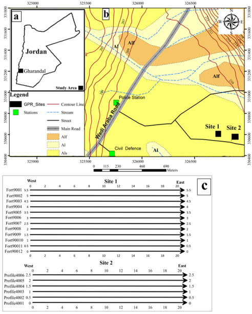
Figure 1. Location map of the study area and the locations for GPR site 1 and 2.
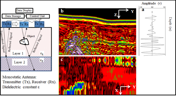
Figure 2. Principles of ground penetrating radar (GPR). a) A-scans displayed varying amplitude with time or depth (vertical). (b) B-scan; a vertical 2D cross-section of stitched together A-scans; also known as “transects” or “plan view.” (c) C-scan; a horizontal 2D cross-section of interpolated B-scans; also known as “depth slices” or “time slices” which is subtract from 3D section.
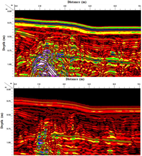
Figure 3. GPR profiles Fort9003 before and after migration.
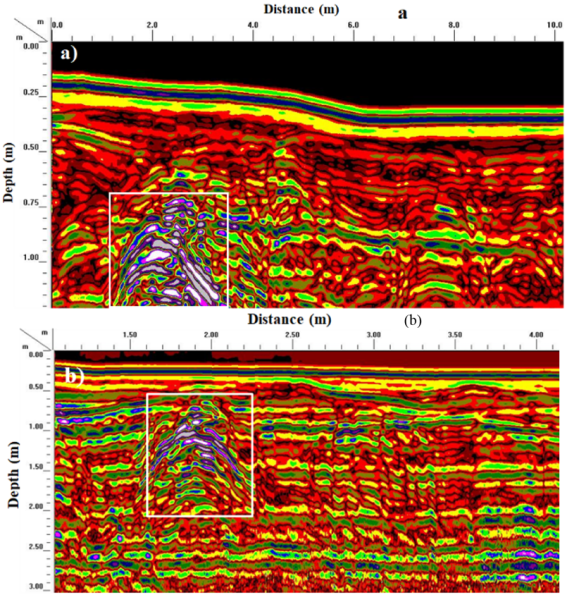
Figure 4. A distinct anomaly, bracketed within the white rectangle. a) A portion of 900 MHz radargram along profile FORT9003 at site 1. The hyperbolic shape anomaly situated at distance between 1.5 m to 2 m and 0.8 to 1.8 m deep, shows a possible grave. b) The same anomaly can be observed along 400 MHz radargram FORT4003 which has the same location as FORT9003.
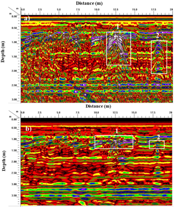
Figure 5. a) A portion of 400 MHz radargram along profile 4004 at site 2. The hyperbolic anomaly at 12.5 m to 0.8 m deep shows a possible grave, the second anomaly at distance 18 m and 1 m deep shows a possible rock. b) The profile 4005 migrated section.
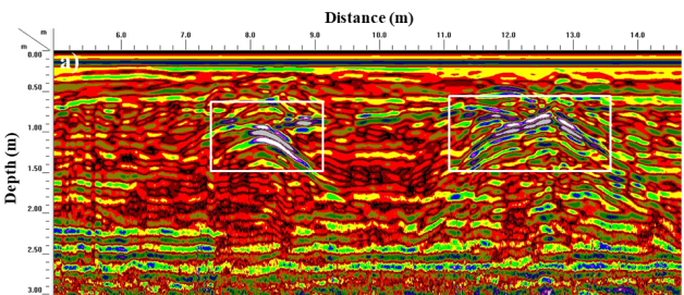
Figure 6. A portion of 400 MHz radargram along profile 4005. Two hyperbolic shape anomalies appear at distance between 7.5 to 9 m and 11 to 13.5 m respectively.
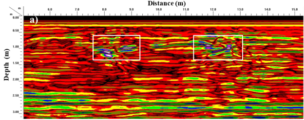
Figure 7. A portion of GPR profile 4005 migrated section. A distinct anomaly is highlighted within within the white rectangle.
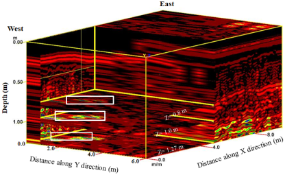
Figure 8. The 3D section (chair view) with x =2: 5, y =0, and different slides depth 0.8, 1 and 1.27 m bellow the ground surface shows the possible grave location (white rectangle).
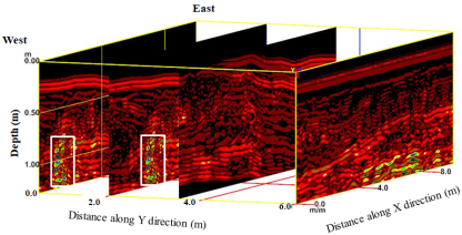
Figure 9. Time slice y-cut display (C-scan) at distance (0, 2, 3.5, and 6 m) determines the location of the possible grave (white rectangle).
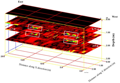
Figure 10. Site 2 400 MHz multi slices (C-scan) view at depths of 0.75, 1.2 and 2 m bellow the ground surface shows the possible two graves location (white rectangle).
Information